Sunderland
Wearmouth Staiths
Last Updated:
1 Apr 2024
Sunderland
This is a
Coal Drops, Staith
54.912043, -1.390621
Founded in
Current status is
Partly Demolished
Designer (if known):

Now a monument to Sunderland's mining heritage
These brick and stone remains and the last of the Wearmouth Staiths, serving the colliery situated at the Stadium of Light which was the deepest mine in the world upon opening and kept the title in this country for some decades. This is the last surviving staith as complete on the whole river.
The colliery itself was in operation from 1835 til 1993 - over 150 years, and in that time millions of tons of coal will have been loaded from this exact spot. You can read more on Wearmouth Colliery on the Coals Archive: https://www.northeastheritagelibrary.co.uk/coalsarchive/2743/wearmouth-colliery
Much of what we see dates around the turn of the 20th century, though it’s worth noting it built on at least one generation before it given the presence of the stone retaining wall on my 2nd shot.
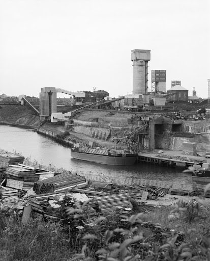
You can see how it looked in its later years on the 3rd shot, with the coal going down a big conveyor belt into the ship holds. Before this, it will have quite literally dropped.
Sadly the complex timber superstructure is lost, though I think we’re lucky to at least have this.
Listing Description (if available)


The banks of the Wear were a constantly evolving place. The Ordnance Survey maps shown date from the 1910s to the 1930s when the Wearmouth Staiths reached their peak, though just before these dates we see a constant evolution. Much of the area around what's now the Stadium of Light, then Wearmouth Colliery, was terraced housing. Much of this accommodated the pit workers, railway workers and those who occupied the brickworks.
You can also see the long winding path down to the Wear between Easington Street and the drops themselves. This still exists, though the Drop Tavern at the bottom was demolished a long time ago. The Wreath Quay Engineering Works were also constructed in the inter war period, and the Hetton Staiths were rationalised.

The Ordnance Survey of 1859 depicts a very different scene to that of 60 years later. The drops were named the "Pemberton Drops" given the pit was at this time called "Pemberton Main Colliery", and were much smaller than later iterations. The site of the more modern drops were a modest shipbuilding yard on Wreath Quay, in an area largely undeveloped. The Drop Tavern was in operation at this time, which stood until the mid 20th century though fell out of use as a pub.

The remains of the coal drop in 2024

Taken by Roger Thomas, Historic England

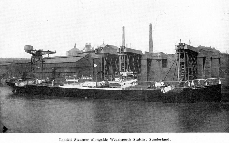
The drops nearby a hammerhead crane sometime in the early to mid 20th century.
Shared online by searlecanada. Original publisher unknown. http://www.searlecanada.org/sunderland/sunderland010.html
