

Bigges Main
The Masons Arms, Bigges Main
Last Updated:
10 Apr 2025
Bigges Main
This is a
Pub
54.995667, -1.552924
Founded in
Current status is
Demolished
Designer (if known):
Now Centurion Park Golf Course
There's no figment of resemblance these days, but in latter years the cornerstone of Bigges Main village was its pub - the Masons Arms.
The pub doesn't date from the inception of the village. This was instead a converted homestead on the old Stable Row, next to where the horses would be kept when they weren't working shifts at the pit. It's also one of the sizeable two storey properties, meaning it may have been home to the farm manager or colliery manager.
It was converted in the 1860s, likely by a Thomas Hedley, originally a builder who died shortly after opening in 1868. What's morbid is that his own inquest was held in the pub he owned. It was found he died of apoplexy after dealing with a violent outbreak at the pub. It was later ran by Septimus Widdrington until 1902.
The clearances began in 1936 and this alongside another large villa become the last remaining vestiges of the once thriving pit village. It continued to boast a good following of customers right until the end. The last landlord was Alan Humphrey, who moved out in the March of 1968 with his family and soon after the Scottish & Newcastle moved in for demolition proceedings.
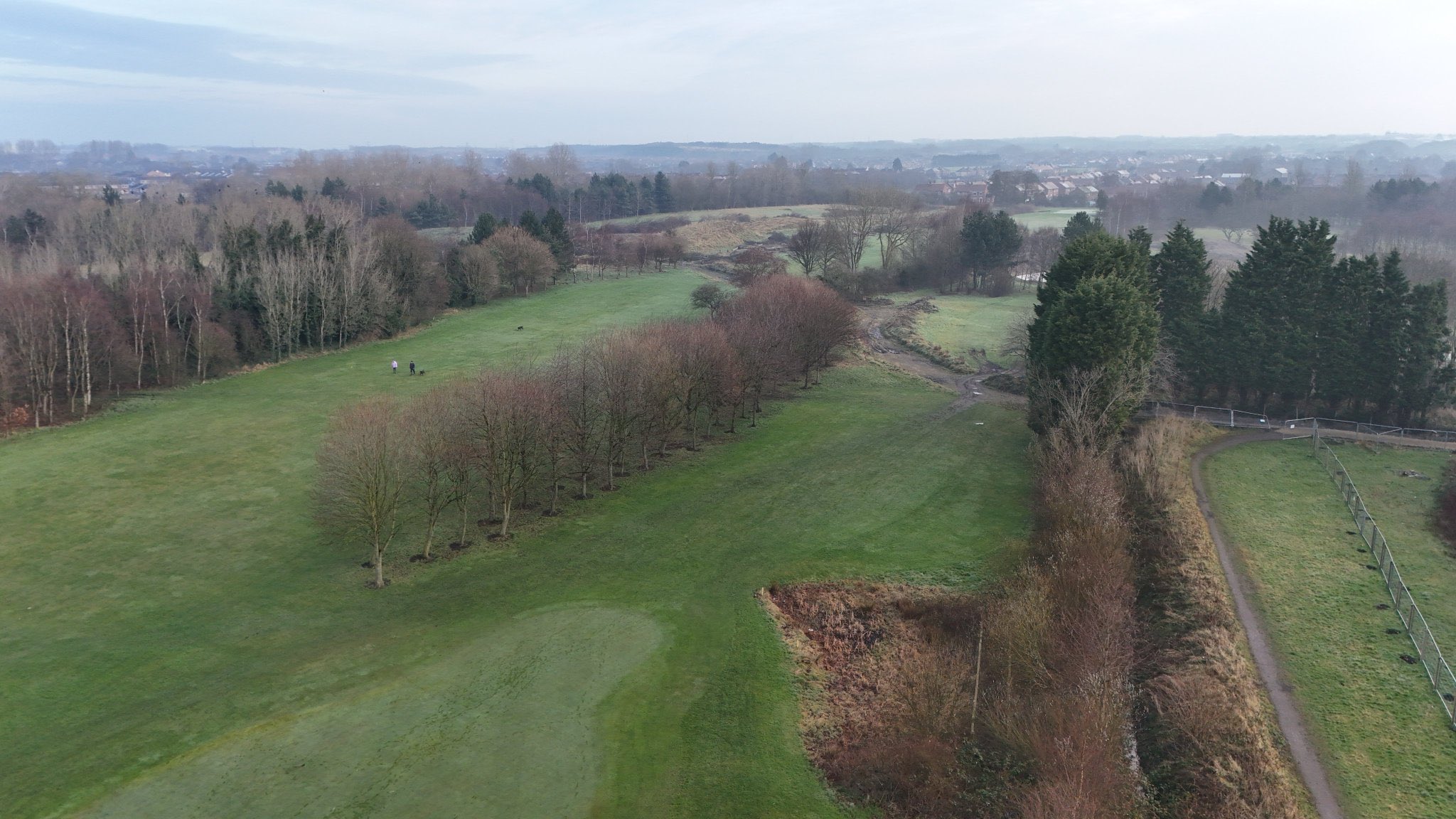
As you can see, nowadays there is absolutely nothing left of the premises or its surroundings. It was all landscaped from the 70s to form the golf club.
History of Bigges Main village
Just north of Wallsend is one of Tyneside’s lost & extinct mining communities, flattened under the Centurion Park golf course.
This was Bigges Main. A colliery stood here from the 1780s when royalties were leased from Thomas Charles Bigge of Benton House, just up the road. He was married to a member of the Ord family too and was High Sheriff of Northumberland for a period. Three shafts were sunk here, and they remained in use until 1856 and connected to the Coxlodge Waggonway. It closed quite early you might say, but there was a chronic issue with flooding leading to its abandonment. The Burn family later took on the royalties, and they in turn leased the rights to the Walker Coal Company in the early 1900s.
As the colliery developed so did the infrastructure. In the early days before widespread steam, colliery farms were required to look after the horses who worked and transported the coal. Houses also needed to be built to accommodate the pit men required to hew the coal underground. Right up until the end of the 19th century this area was rural, so it was quite tricky to scale up the enterprise while not allowing a place to settle nearby. This is how the village grew, and follows a trend of most others in the region.
A good few hundred workers lived here at its peak, and with it came everything you’d expect from a pit village. Pubs, a post office and even a tramway from Wallsend while it still had a decent population in the late 19th century. They had their own football team too - Bigges Main Celtic.
The population very steadily declined from the early 20th century. The houses were decrepit and there was only a handful of people here in the 1960s, though the area was still known as Bigges Main.
Wallsend Council compulsory purchased the land procedurally through the 1960s, reinventing the village and surrounding agriculture for sports grounds and a golf course. As such Wallsend Boys Club and the (currently in redevelopment) Centurion Park now reside in the grounds
Listing Description (if available)


The maps shown here present Bigges Main from the mid 19th century all the way through to the end. You'll notice there was marginally change, as the village was very much stagnant after the closure of the pit in the 1850s, and ceased to have its underpinning industry. Rather, the community stuck it out and likely commuted to work in Wallsend, Benton or Heaton.
Remarkably, despite the pit closing in the 1850s everything remained intact for the next half century. The Masons Arms, which was the large building at the corner of the row adjacent to the chapel & school, remained surrounded by late 18th/early 19th century rows and cottages and allotments. Even the route of the waggonway which had been pulled up some decades prior was in situ.
Unfortunately the Masons Arms is not labelled on either map, but was certainly operational by the 1860s.

Sirens were starting to sound by the 1930s. The Masons Arms, alongside a large villa to the north, were the last remaining occupied properties at Bigges Main. There is sweeping change going on - the development of the coast road and the urban developments of Wallsend were encroaching on this one green oasis between provincial settlements. By this stage, there won't have even been a dozen people living at Bigges Main but the pub was still well frequented into the 60s.
The pub was in the centre left of this aerial shot, just by the tree line. Taken in March 2025
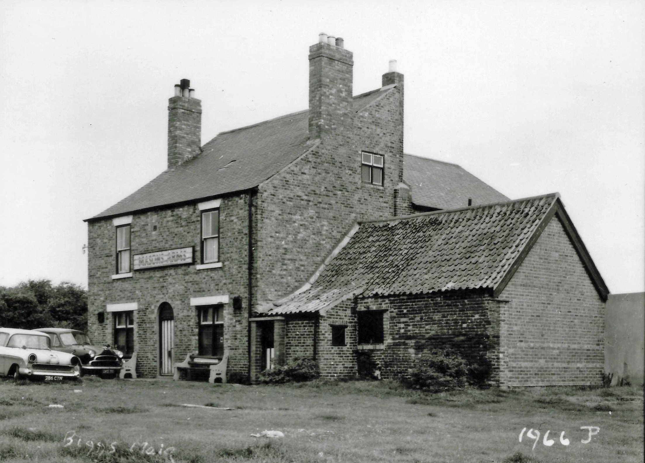
Photograph from 1966 courtesy of Steve Ellwood @TyneSnapper (Jack & Geoff Phillips Collection)
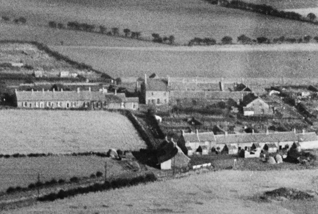
Aerial photograph of Bigges Main in 1927, with the Masons Arms the dominant feature of the village. Source: © Historic England. Aerofilms Collection EPW019789 flown 20 October 1927