top of page

Shildon, County Durham

Shildon Coal Drops

Last Updated:

9 Oct 2023

Shildon, County Durham

This is a

Coal Drops

54.626216, -1.638114

Founded in 

1846

Current status is

Extant

Designer (if known):

4076554724_b6df6c95d4.jpg

Listed Grade II*

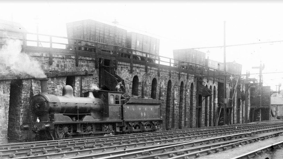
These are the first purpose built tender coal drops on the planet, built 1846 for the Stockton and Darlington Railway to refuel locomotives. Coal held in a wagon would fall down the chute into a waiting tender. Before this it was shovelled in by hand, vastly speeding up the process. Though there are earlier drops, namely at Oakwellgate at Gateshead and along the Stanhope and Tyne Railway, these are known to be the first drops specifically to add coal to a tender. A tender is where the coal is stored behind the locomotive engine.

The marshalling yard at Shildon was huge and speed was key to distribute coal quickly to Darlington and Middlesbrough. Thanks to it being a central junction between the Stockton & Darlington Railway, the Surtees Railway and the Black Boy Colliery Railway it was also a site with an abundance of coal at hand, making it an easy decision to erect the drops here.

It was the first known attempt to mechanise the process which was time consuming and inefficient, and meant yardmen could focus their attention elsewhere.

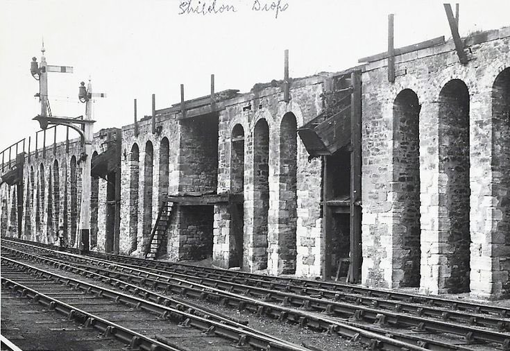
Though the chutes themselves no longer survive, the stone structure does and is a key part of the Shildon railway heritage attraction. With this said, some iron brackets and fittings do survive embedded in the masonry.

Heritage services for the National Railway Museum will potentially be running past here again as of 2023.

Listing Description (if available)

The locomotive coaling drops are thought to have been built in 1846, and to have been commissioned by William Bouch (1813-1876), the Stockton & Darlington Railway (S&DR) Superintendent of Locomotives from 1840. The coaling drops were specifically designed for refuelling steam locomotives: coal waggons on a railway siding that ran along the upper surface of the structure were discharged by gravity into hoppers sited in the alcoves below. These hoppers fed into chutes set above the line which ran along immediately to the south of the drops, the chutes allowing the swift refuelling of steam locomotives waiting below. The fourth, larger alcove is shown in early photographs to have contained a raised platform accessed by staircases, this platform was possibly designed for manual refuelling of locomotives with bunkers too small for the chutes. Previously all locomotives would have been refuelled via manual shovelling from line-side bunkers: the Dixon plan of 1839 appears to show a set of such bunkers to the west of the site of the coaling drops. Refuelling steam locomotives using manual labour rather than gravity feeds or some form of mechanisation was surprisingly common and persisted elsewhere nationally into the C20, even on some major railways. The structure included three sets of drops with chutes, probably to improve efficiency, but possibly to allow for differing grades of fuel or tender capacities: locomotives designed to haul passenger trains generally used higher grade fuel than slower goods engines. The track layout, depicted on Ordnance Survey maps, suggests that the refuelling of multiple locomotives simultaneously would have been impractical. Mapping shows that the line to the top of the coaling drops was a siding leading off from the Black Boy incline, suggesting that the fuel mainly came from the collieries to the north of Shildon that were served by the Black Boy branch line. It is even possible that the structure was originally designed so that loaded coal wagons were run to the top of the drops via gravity using momentum gained from descending the incline, an approach used elsewhere in the North East in the C19. The coaling drops can be identified on the first edition 1:10560 Ordnance Survey map which was surveyed in 1857, with the track layout still in place when resurveyed in 1939 suggesting that it was still operational into the mid-C20. Map evidence indicates that the track was lifted from the coaling drops sometime before 1962. Early photographs show that at the far eastern end of the structure the end of the siding was carried on two free-standing piers that were in the area now built up as an earthen embankment. The pioneering S&DR started commercial operation in 1825. Although initially mainly operated with horse-haulage combined with steam-powered, rope-worked inclines, the company championed the use of steam locomotives from the beginning. Through its policy of freely sharing information with visiting engineers and railway promoters, the S&DR was highly influential in the early establishment of other railways both in England and abroad, being described by Henry Booth of the Liverpool and Manchester Railway in 1831 as ‘the great theatre of practical operations on railways’. Subsequently the S&DR’s pivotal role in railway history has been marked by major celebrations every 50 years, including the opening of the National Railway Museum in 1975. Details Coal drops for refuelling steam locomotives, 1846 commissioned by William Bouch for the Stockton & Darlington Railway. MATERIALS: sandstone rubble, mainly buff coloured, including some reused former sleeper stones, and buff coloured brick. DESCRIPTION: the structure appears as a south-facing, stone-built revetment forming an incline that starts at the west-north-west end to rise and gently curve to the east. By the mid-point of the structure the incline has reached its full height, the eastern half extending at this level eastwards. It is constructed as a regular series of engineering arches with semi-circular heads formed from triple courses of brick headers, the piers generally being quoined. There are thirty of these arches forming the inclined western half. The eastern half of the structure is also mainly formed from similar regular engineering arches, but includes four rectangular, deep, open-topped alcoves marking the positions originally occupied by the coal drop hoppers. The first coal drop alcove is at about the mid-point of the structure, the next is sited after ten engineering arches, the eastern three alcoves then each separated from the next and the end by sets of three arches. The third alcove, which may not have been a coal drop, is nearly twice the width and depth of the other three alcoves and retains a ledge that formally supported staging. A number of the engineering arches are blocked with later masonry and buttressing. The structure retains a few iron brackets and other fragmentary fittings, but no longer retains chutes or hoppers.

The Ordnance Survey maps above illustrate the Soho Works are from the mid 19th century through to the turn of the 1900s. The coal drops are illustrated, but not labelled.

The layout is very much retained through the decades, but gets gradually more dense with the inclusion of Shildon Colliery and the Marshalling yards to the east. The village of New Shildon itself also expands significantly with the growth of industry in the town, complete with another colliery near the Shildon Brickworks. By the 1890s Shildon was outgrowing itself. The Sebastapol roundhouse in the west of the village was replaced with Shildon Wagon Works.

This map was published in 1924 but was surveyed just before WWI. Little had changed since the 1890s, but further amenities can be spotted for the people of Shildon as they started to strive for a better standard of living outside of work. A golf course can be seen, alongside a number of churches. Just outside of view there was a football ground at Shildon Wagon Works.

The coal drops were still operating at this time.

4076554724_b6df6c95d4.jpg

The Shildon Coal Drops in 2023

4076554724_b6df6c95d4.jpg

The drops in 1932. Source: Darlington Railway Museum
4076554724_b6df6c95d4.jpg

The drops next to wooden semaphore signals. Undated but picture quality indicates 20s-30s. Source: Durham University

bottom of page