

Ryhope, Sunderland
Ryhope Pumping Station
Last Updated:
19 Jun 2023
Ryhope, Sunderland
This is a
Pumping Station
54.865421, -1.372130
Founded in
Current status is
Preserved
Designer (if known):
Thomas Hawksley
Grade II* Listed
The Victorians didn’t do things by halves did they, even for a basic utility! This is the Ryhope Pumping Station, built in 1868 to supply water to Sunderland and ran til the 60s. The Industrial Revolution brought the fruits of wealth and mass population growth to Sunderland and its surrounding areas. Domestic requirements surged with fresh water, sanitation and utilities required on a larger scale than ever before.
Previously, more concentrated local water supplies were used. Wells and springs were exploited by local villages (consider Cox Green and Pennywell) as well as rivers and surface reservoirs. The geology of the North East also helped, with fresh water lying underground in magnesium limestone.
The Sunderland and South Shields Water Company were founded in 1852 to increase capacity and improve the water supply to the regional population.
Ryhope Pumping Station was one of many cropping up at the time. The company received royal assent and in 1864 four acres of land were sought to relieve the pressures and quickly construct. The construction was complicated - the ultra-modern beam engines were entirely inter-dependent with the building and foundations themselves so had to be fitted and built together without interfering with the sinking of the deep wells. It was, however, ultimately successful of course.
The engines were constructed by Hawthorn's of Newcastle (either at St. Peter's or Forth Banks near Central Station) and were said to have been "the finest compound beam engines in Britain". A forge, boilers, waterwheel and a number of steam engines are also located at the site. There are other similar examples at Wylam and Tees Cottage.
The station was discontinued in 1967 for a number of reasons, but namely thanks to the quality of water. Its magnesium limestone source made it 'hard', which was further accentuated by the opening of the Derwent and Kielder reservoirs which provided fresh water to the region.
The site is still owned by Northumbrian Water but managed as a museum, featuring the beam engines in working order.
Listing Description (if available)


The two Ordnance Survey maps above illustrate the Ryhope area after and before the advent of the pumping station. The 2nd image shows the area around a decade before it was constructed. The quarries provide a definite understanding of the rich limestone deposits thanks to the multiple quarries dotted around. It was still incredibly rural in this area, which was probably ideal for it to be away from the centre of the village.
The 1890s map is much more recognisable. The quarries were out of use by this point with the limestone serving a separate purpose. The Sunderland Asylum (later the Cherry Knowle Hospital) opened a couple of years before the area was surveyed which has since been demolished.

The term "lunatic asylum" had become unfashionable by the time this Ordnance Survey was published in 1919. Some terraced rows had been constructed adjacent to the pumping station likely for the workers of the station or the hospitals. Apart from this little more had changed in the couple of decades, though in the inter-war period residential developments started cropping up a little closer to the station.
The Pumping Station in 2023, with the handsome pumping lodge at the entrance to the complex.
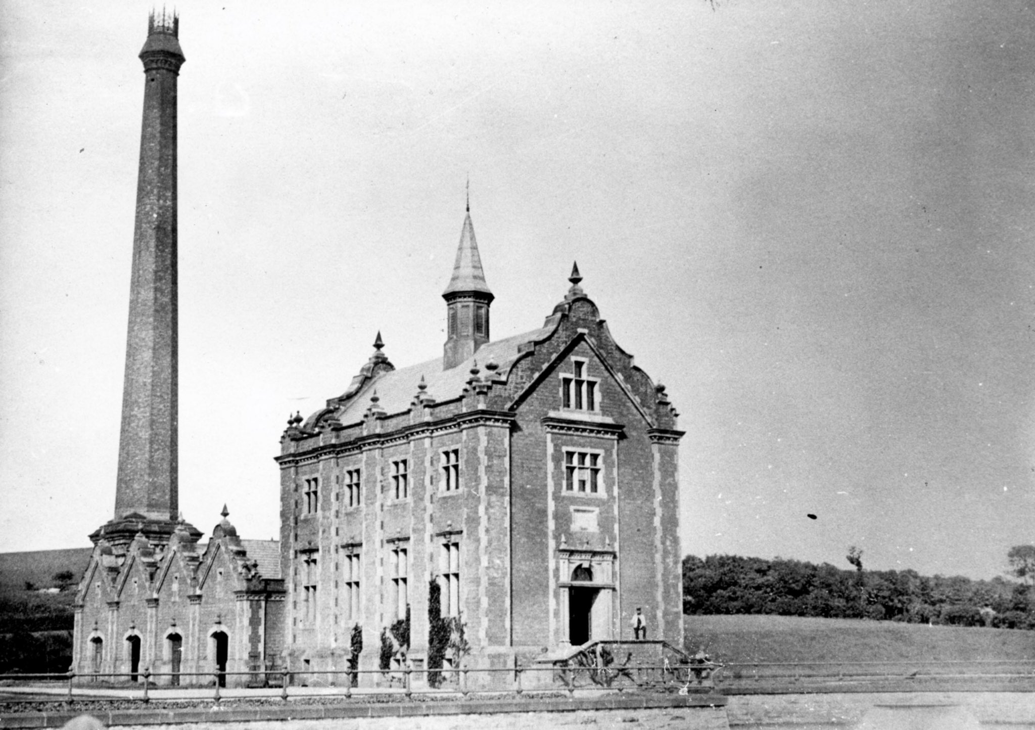
Photograph of the Pumping Station just after construction completed. Source: Ryhope Engines Museum
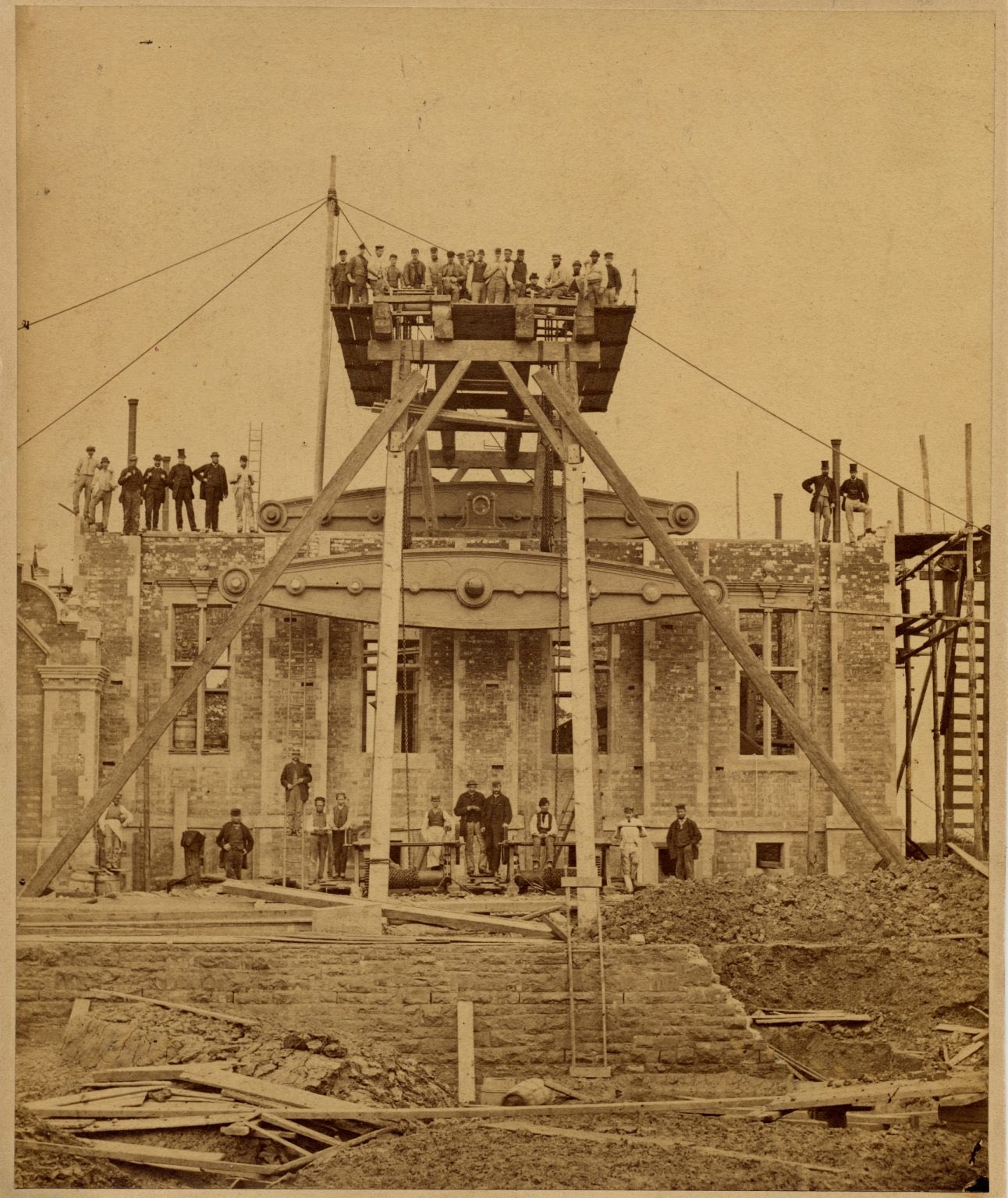
During placement of the south beam engine into place during the 1860s. Source: Ryhope Engine Museum