

Alnwick
Alnwick Baptist Chapel
Last Updated:
21 Feb 2025
Alnwick
This is a
Chapel, Place of Worship
55.410609, -1.708091
Founded in
Current status is
Extant
Designer (if known):
Listed Grade II
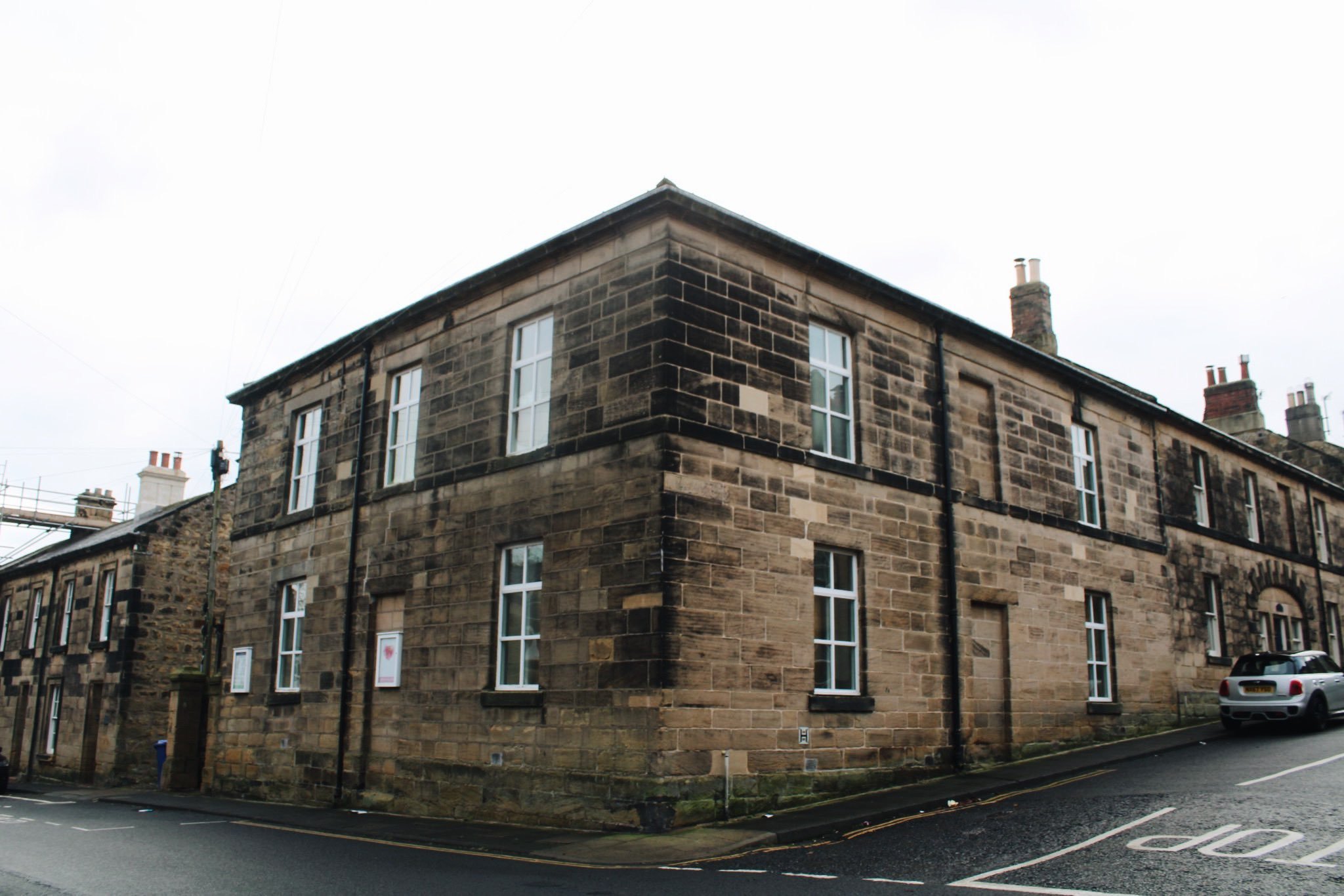
This plain but imposing corner building on Lisburn Street is Alnwick’s Baptist Chapel. It dates from 1837, making it deceptively older than St Paul’s, just a few metres to the east.
It was originally a Presbyterian meeting place—a denomination with a rich history in Alnwick, given its closeness to the Scottish border. The denomination first met at Pottergate in the 1600s, with a formal meeting house rebuilt there in the 1780s. Later, St James’ was built in its place.
The Presbyterian movement was quite fractious and prone to splintering, leading to the emergence of numerous offshoots. A separate branch popped up at St Michael’s Lane, with others on Green Batt and then Clayport. This building, though, was linked to the Scottish Secessionist Relief Church—more closely tied to those north of the border than some of its Alnwick counterparts. Even I find it a bit confusing!
In 1847, a union between the United Secession Church and the Relief Church formed the United Presbyterian Movement. This congregation grew to a respectable size, with 300 people attending an associated event at the Town Hall in 1849. However, this site became the junior one, overshadowed by the larger United Presbyterian church at Clayport, which still stands today.
The church became redundant by the 1880s, as there was little need for two sites. It was then handed over to the Baptist Church—another Protestant denomination. A revival of the church in Alnwick led to a congregation of around 200 by 1891, having previously met in theatres and similar venues.
I’m glad to see the congregation still worshipping in this building, though you’d hardly guess it from the outside. They also host community events like kids’ functions and coffee mornings, which is lovely to see. I think I need a lie-down after trying to unravel Alnwick’s Presbyterian history, though! 😴
Listing Description (if available)


Both these Ordnance Survey plans were surveyed in the mid 19th century - the first in 1851 and the second in 1864. On both, you'll notice the Presbyterian movement was still undergoing pretty substantial change, and went on to be referred as both the United Secession chapel and the United Presbyterian chapel. It all gets a bit confusing!
As you can see, the church marked the fringes of Alnwick at that stage. Though there were a couple of terraces and villas beyond, it was the last ever-moving frontier when developments were edging up Hope House Lane. Over the course of the next decade Howick Street would be expanded at a gentle pace, while Percy Place would reach what is now Clifton Terrace but then was the private lane to Bellevue. It was owned by Captain Gerard Selby - a landowner, philanthropist and naval captain.

Though the 1890s Ordnance Survey doesn't provide as much clarity, it still provides us a template for the growth Alnwick was experiencing while also giving an insight into the old burgage plots seen from Clayport leading up to Lisburn Street. Howick & Percy Street had reached their greatest extent by this decade, and the new Duke's School would be built around a decade later replacing the building on the Green Bat. Our chapel is unlabelled but operating on the corner of Lisburn & Howick Street.
The unemotional Alnwick Baptist Church in February 2025
