

Alnwick
26 Bailiffgate, Alnwick
Last Updated:
3 Mar 2025
Alnwick
This is a
Pub, Dwelling
55.416272, -1.709941
Founded in
Current status is
Extant
Designer (if known):
Grade II listed
One of Alnwick's long-lost historic pubs was the Red Lion, which was situated at 26 Bailiffgate with the building surviving today on the left of my shot.
Though the present iteration dates from the early 19th century, the Red Lion is known to have stood here since at least 1760 in an earlier stone construction. It was opened by a James Hindmarsh "in a very commodious and genteel manner for the reception of the nobility, gentlemen, travellers, and others travelling the great northern road". He served wines, rum, and brandy and supplied stabling facilities for about 30 horses, a coach house, and a post-chaise. This was a carriage to dispatch your own mail to another posting station, which was unknown to me before this. It shows this place was pretty upmarket, and I'm sure took up a fair amount of the real estate this side of Bailiffgate given the capacity of the facilities.
By 1790, the landlord was Matthew Mills. His primary vocation was as a mason, and according to the local history society, he supported the restoration of Alnwick Castle, St Michael's Pant, and Brizlee Tower. It was sometime after this that the coaching inn was rebuilt as part of the terrace, seemingly much more modest than the previous iteration. In fact, you can still see many of his statues and gnomes dotted around Hulne Park (thanks to Nick Lewis for this info! @nick-overthere.bsky.social).
It remained in use until around the early 1870s. We can see it on the 1860s town plan with some sort of snicket through the middle of the building leading to the yard, where presumably there remained some stabling and multiple coal houses for all the roaring fireplaces inside. This archway has been filled in, but it is still legible in the stonework.
Little more is known about its closure though, and by the 1880s, it was home to Reverend E Hicks - St Michael's Curate.
Listing Description (if available)


These maps shown illustrate the Bailiffgate area from the 1850s to the 1890s. You'll notice little changed too, and many of these structures still remain and are listed. Bailiffgate was previously seperate from the township outside of the walls, with Pottergate Tower and Narrowgate Tower about 50 metres south. This was actually where soldiers were accommodate when they couldn't fit within the castle, and provided lodgings for those attending the baronial courts. As a result, it featured the required infrastructure if entrance to Alnwick was not possible in the 18th century, such as a market. Our buildings come slightly after, though some buildings on the eastern side of the street do date from the 1700s.
By the 1890s, the pub was no longer extant and the archway filled in.

The mid 20th century Ordnance Survey map again reinforces the sparse change to this area since the early 19th century. The old library was demolished for guild rooms which later became a club, and a series of academic establishments are annotated on the eastern side of the road, though they were here in the 19th century too.
26 Bailiffgate is shown at the left of this photograph, though the Red Lion encompassed the buildings adjoining too. The archway is quite legible with the different grade of stonework around the ground floor window. Taken in February 2025.
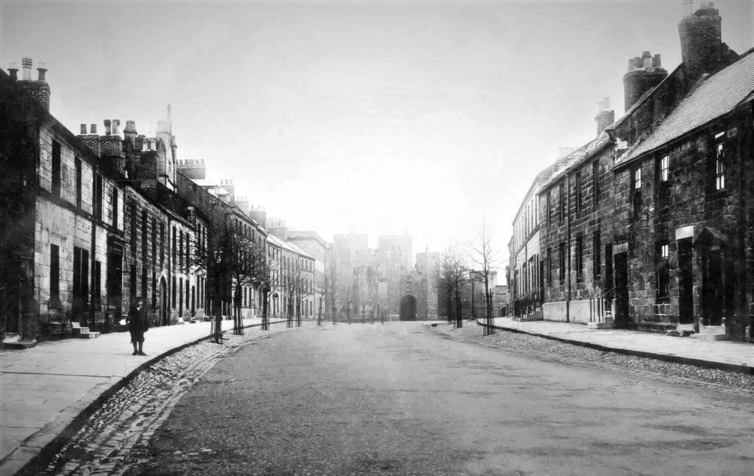
A late 19th century view of Bailiffgate, unknown photographer. The same filled in archway is visible on the building on the extreme left.
